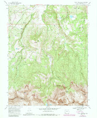
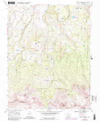
1967 Map of Mount Sneffels
USGS Topo · Published 1984About this map
Miller Mesa and the surrounding high-altitude drainage systems of the San Juan Mountains dominate this survey, recorded in the mid-1960s with 1980s updates. The landscape is defined by the three branches of Dallas Creek, which carved deep valleys beneath the peaks of the Uncompahgre National Forest. Human presence is marked by isolated sites such as Vance Place and several high-country camps, including McClure Camp and Kelly Camp. The southern portion of the map transitions into the steep, glacial topography of the Mount Sneffels Wilderness, where the Blaine Mine sits in the shadows of Mount Sneffels and Mount Ridgway. Notable water resources include high alpine features like Lake Otonawanda and the Blue Lakes, along with several stock-management structures such as the Upper Desert Tank and Lower Desert Tank.
Find a feature on this map
44 named features on this map. Tap any name to fly to it.
Don’t see what you’re looking for? This feature index may not catch every label — zoom into the map to look around manually.
Map Details
Editions of this 1967 Mount Sneffels Map
5 editions found
Other maps of this area

1897 · Telluride
USGS Topo · 1:62,500

1897 · Silverton
USGS Topo · 1:62,500

1901 · Silverton
USGS Topo · 1:62,500

1902 · Silverton
USGS Topo · 1:62,500

1902 · Ouray
USGS Topo · 1:62,500

1904 · Ouray
USGS Topo · 1:62,500

1904 · Telluride
USGS Topo · 1:62,500

1909 · Montrose
USGS Topo · 1:125,000

1911 · Montrose
USGS Topo · 1:125,000

1945 · Durango
USGS Topo · 1:250,000