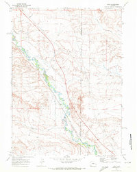
1969 Map of Moxa
USGS Topo · Published 1972About this map
Hams Fork meanders through this High Plains landscape, its winding course defining the agricultural and industrial infrastructure of the region during the late 1960s. The presence of numerous irrigation channels, such as the Ziegler and Capen Ditch and the Moore and Bagley Ditch, reveals an intricate water management system designed to support ranching operations along the river valley. Parallel to the water, the Union Pacific railroad and a prominent north-south Pipeline underscore the area's role as a vital transportation and energy corridor.
Find a feature on this map
16 named features on this map. Tap any name to fly to it.
Don’t see what you’re looking for? This feature index may not catch every label — zoom into the map to look around manually.
Map Details
Editions of this 1969 Moxa Map
2 editions found
Other maps of this area

1954 · Ogden
USGS Topo · 1:250,000

1954 · Rock Springs
USGS Topo · 1:250,000

1958 · Ogden
USGS Topo · 1:250,000

1958 · Rock Springs
USGS Topo · 1:250,000

1960 · Ogden
USGS Topo · 1:250,000

1961 · Sevenmile Gulch
USGS Topo · 1:24,000

1961 · Granger
USGS Topo · 1:24,000

1962 · Rock Springs
USGS Topo · 1:250,000
1963 · Whiskey Buttes
USGS Topo · 1:24,000

1969 · Church Butte NW
USGS Topo · 1:24,000