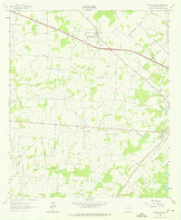
1962 Map of Myrtle Springs
USGS Topo · Published 1976About this map
Myrtle Springs sits at the heart of this East Texas landscape, where the headwaters of numerous creeks begin their winding paths through Van Zandt County. The map reveals a transition from the rural community of Wallace to the developing outskirts of Canton in the southeast. Water defines the topography, with Lacy Fork and its various branches, such as Wet Lacy Fork and Dry Fork, carving out lowlands between the upland ridges. Local roads like Hayden Road and Highland Road connect several rural landmarks, including Hayden Ch and Wesley Chapel. The presence of High Cem and the Wesley Chapel Cemetery provides valuable data for genealogists tracing early families in the region. Further south, the map captures the edge of local recreation and utility with Roadside Park and the municipal City Lake.
Find a feature on this map
36 named features on this map. Tap any name to fly to it.
Don’t see what you’re looking for? This feature index may not catch every label — zoom into the map to look around manually.
Map Details
Editions of this 1962 Myrtle Springs Map
3 editions found
Other maps of this area

1920 · Kemp
USGS Topo · 1:62,500

1948 · Martins Mill
USGS Topo · 1:62,500

1949 · Martins Mill
USGS Topo · 1:62,500

1954 · Dallas
USGS Topo · 1:250,000

1956 · Tyler
USGS Topo · 1:250,000

1957 · Kemp
USGS Topo · 1:62,500

1958 · Dallas
USGS Topo · 1:250,000

1962 · Myrtle Springs
USGS Topo · 1:24,000

1962 · Prairieville
USGS Topo · 1:24,000

1962 · Cedarvale
USGS Topo · 1:24,000