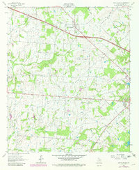
1962 Map of Myrtle Springs
USGS Topo · Published 1982About this map
Myrtle Springs and the northern edge of Canton anchor this 1962 Van Zandt County survey, which was later updated in the early 1980s to reflect changes in woodland and infrastructure. The landscape is defined by the complex drainage of the Lacy Fork and its numerous tributaries, including Dry Fork, Wet Lacy Fork, and Coppers Branch. These waterways weave through a rural network of family-named roads like Hayden Road and Dewberry Lane, suggesting a landscape of long-standing family landholdings and small-scale agriculture.
Find a feature on this map
27 named features on this map. Tap any name to fly to it.
Don’t see what you’re looking for? This feature index may not catch every label — zoom into the map to look around manually.
Map Details
Editions of this 1962 Myrtle Springs Map
3 editions found
Other maps of this area

1920 · Kemp
USGS Topo · 1:62,500

1948 · Martins Mill
USGS Topo · 1:62,500

1949 · Martins Mill
USGS Topo · 1:62,500

1954 · Dallas
USGS Topo · 1:250,000

1956 · Tyler
USGS Topo · 1:250,000

1957 · Kemp
USGS Topo · 1:62,500

1958 · Dallas
USGS Topo · 1:250,000

1962 · Myrtle Springs
USGS Topo · 1:24,000

1962 · Prairieville
USGS Topo · 1:24,000

1962 · Cedarvale
USGS Topo · 1:24,000