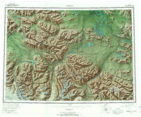
1960 Map of Nabesna
USGS Topo · Published 1967About this map
Nabesna Village and Northway Indian Village anchor the human geography of this interior Alaskan landscape, which spans the intersection of the Mentasta Mountains and the Wrangell Mountains. The map documents a period when regional travel relied on a mix of the Alaska Highway, the Glenn Highway, and a network of tractor trails and winter trails that connected remote outposts. Significant cultural landmarks like Duffy's Tavern, Seaton Roadhouse, and the Border City Trading Post appear alongside the vast Tetlin Indian Reservation, illustrating the era's frontier commerce and traditional lands. From the heights of Nabesna Mountain to the braided waters of the Nabesna River and Chisana River, the survey captures a topography defined by immense glaciers and high-altitude passes, including Mentasta Pass and Cooper Pass, which dictated the routes of early mid-century explorers and residents.
Find a feature on this map
141 named features on this map. Tap any name to fly to it.
Don’t see what you’re looking for? This feature index may not catch every label — zoom into the map to look around manually.
Map Details
Editions of this 1960 Nabesna Map
5 editions found

Other maps of this area

1948 · Tanacross A-6
USGS Topo · 1:63,360

1948 · Tanacross A-3
USGS Topo · 1:63,360

1948 · Tanacross A-4
USGS Topo · 1:63,360

1948 · Nabesna C-6
USGS Topo · 1:63,360

1948 · Nabesna D-5
USGS Topo · 1:63,360

1948 · Tanacross A-5
USGS Topo · 1:63,360

1949 · Tanacross
USGS Topo · 1:250,000

1949 · Nabesna D-6
USGS Topo · 1:63,360

1949 · Tanacross A-5
USGS Topo · 1:63,360

1949 · Gulkana C-1
USGS Topo · 1:63,360