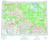
1960 Map of Nabesna
USGS Topo · Published 1982About this map
Nabesna Village and several traditional settlements including Charleskin Village and Eltia Village anchor this mid-century survey of the eastern Alaska interior. The landscape is defined by the convergence of major mountain systems, where the Mentasta Mountains meet the Nutzotin Mountains and the volcanic peaks of the Wrangell Mountains, such as Tanada Peak and Mt Gordon. The transportation network of the era is clearly visible, with the Glenn Highway and Alaska Highway skirting the highlands, while the Nabesna Road provides access to the mining and hunting camps near the headwaters of the Nabesna River. Notable roadside landmarks of the period, such as Duffys Tavern and Scottie Creek Lodge, serve as key orientation points for travelers navigating the wilderness boundaries of the Tetlin Indian Reservation and the Wrangell-St Elias National Park and Preserve.
Find a feature on this map
121 named features on this map. Tap any name to fly to it.
Don’t see what you’re looking for? This feature index may not catch every label — zoom into the map to look around manually.
Map Details
Editions of this 1960 Nabesna Map
5 editions found

Other maps of this area

1948 · Tanacross A-6
USGS Topo · 1:63,360

1948 · Tanacross A-3
USGS Topo · 1:63,360

1948 · Tanacross A-4
USGS Topo · 1:63,360

1948 · Nabesna C-6
USGS Topo · 1:63,360

1948 · Nabesna D-5
USGS Topo · 1:63,360

1948 · Tanacross A-5
USGS Topo · 1:63,360

1949 · Tanacross
USGS Topo · 1:250,000

1949 · Nabesna D-6
USGS Topo · 1:63,360

1949 · Tanacross A-5
USGS Topo · 1:63,360

1949 · Gulkana C-1
USGS Topo · 1:63,360