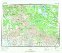
1960 Map of Nabesna
USGS Topo · Published 1970About this map
The Tetlin Indian Reservation occupies a massive central expanse of this 1960s study, where the Chisana River and Nabesna River meet to form the headwaters of the Tanana. This subarctic landscape is defined by the convergence of the Mentasta Mountains and the Wrangell Mountains, creating a complex network of high passes like Mentasta Pass and Suslota Pass. Small settlements and native villages such as Northway Indian Village, Nabesna Village, and Charleskin Village are scattered throughout the river lowlands, while the mining and bush-pilot legacy of the region is centered at Nabesna and Chisana. Transport is dominated by the Glenn Highway in the west and the Alaska Highway in the northeast, though much of the interior relies on a Winter Trail or Tractor Trail. Noteworthy landmarks include Orange Hill and the remote Devils Mountain Lodge, marking a period when these interior lands remained largely wild and accessible only by water, trail, or air.
Find a feature on this map
139 named features on this map. Tap any name to fly to it.
Don’t see what you’re looking for? This feature index may not catch every label — zoom into the map to look around manually.
Map Details
Editions of this 1960 Nabesna Map
5 editions found

Other maps of this area

1948 · Tanacross A-6
USGS Topo · 1:63,360

1948 · Tanacross A-3
USGS Topo · 1:63,360

1948 · Tanacross A-4
USGS Topo · 1:63,360

1948 · Nabesna C-6
USGS Topo · 1:63,360

1948 · Nabesna D-5
USGS Topo · 1:63,360

1948 · Tanacross A-5
USGS Topo · 1:63,360

1949 · Tanacross
USGS Topo · 1:250,000

1949 · Nabesna D-6
USGS Topo · 1:63,360

1949 · Tanacross A-5
USGS Topo · 1:63,360

1949 · Gulkana C-1
USGS Topo · 1:63,360