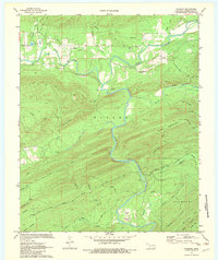
1972 Map of Nashoba
USGS Topo · Published 1983About this map
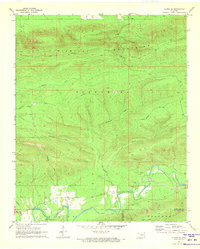
Nashoba and Nolia anchor this Pushmataha County landscape in the early 1970s, where the Little River and Black Fork carve through the Kiamichi mountains. This survey reveals a rural economy transitioning from traditional agriculture to specialized land uses, evidenced by Fish Farms and several Shale Pits scattered near the settlements. The presence of Black Fork Cem and Nolia Cem provides essential grounding for family researchers, while the winding Nolia Road and Pickens Road connect these small communities to the broader region. The map also highlights the recreational and residential development of the era, from the Trails End Camp to the more formal Little River Ranch, complete with its own private Landing Strip. Local movement was still heavily dictated by the terrain, with the Paul Stevens Trail and other unmarked paths cutting across ridges like Musket Mountain.
Find a feature on this map
41 named features on this map. Tap any name to fly to it.
Don’t see what you’re looking for? This feature index may not catch every label — zoom into the map to look around manually.
Map Details
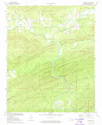
Editions of this 1972 Nashoba Map
2 editions found
Other maps of this area

1901 · Tuskahoma
USGS Topo · 1:125,000

1901 · Alikchi
USGS Topo · 1:125,000

1908 · Tuskahoma
USGS Topo · 1:125,000

1909 · Tuskahoma
USGS Topo · 1:125,000

1950 · Mcalester
USGS Topo · 1:250,000

1962 · McAlester
USGS Topo · 1:250,000
1962 · Caney Mountain
USGS Topo · 1:24,000
1962 · Signal Mountain
USGS Topo · 1:24,000

1965 · McAlester
USGS Topo · 1:250,000
1971 · Albion SE
USGS Topo · 1:24,000