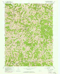
1964 Map of New Freeport
USGS Topo · Published 1973About this map
Deep valley drainages and an extensive network of gas wells define this 1960s landscape in southwestern Greene County. At the confluence of Pennsylvania Fork Fish Creek and Hamilton Run, the village of New Freeport serves as a local hub near the Springhill Freeport Sch. The topography is shaped by the winding South Fork Dunkard Creek and Mt Carmel Ridge, which separate various townships including Aleppo and Springhill.
Find a feature on this map
51 named features on this map. Tap any name to fly to it.
Don’t see what you’re looking for? This feature index may not catch every label — zoom into the map to look around manually.
Map Details
Editions of this 1964 New Freeport Map
3 editions found
Other maps of this area

1903 · Littleton
USGS Topo · 1:62,500

1904 · Cameron
USGS Topo · 1:62,500

1905 · Mannington
USGS Topo · 1:62,500

1905 · Rogersville
USGS Topo · 1:62,500

1905 · Littleton
USGS Topo · 1:62,500

1923 · Mannington
USGS Topo · 1:62,500

1924 · Littleton
USGS Topo · 1:62,500

1926 · Littleton
USGS Topo · 1:62,500

1926 · Mannington
USGS Topo · 1:62,500

1935 · Cameron
USGS Topo · 1:62,500