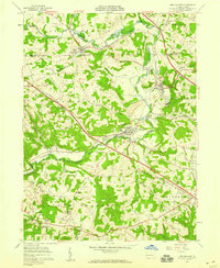
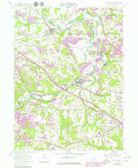
1957 Map of New Galilee
USGS Topo · Published 1959About this map
Industrial and rural landscapes intersect along the Little Beaver River in this 1957 study of western Pennsylvania. The Pennsylvania Railroad and the Youngstown and Southern Railway define the local transport network, linking the borough of Enon Valley with the active industrial centers of New Galilee and Darlington. The map reveals a land heavily utilized for natural resources, evidenced by numerous Strip Mines and Brick Kilns scattered throughout the valleys of Beaverdam Run and Madden Run.
Find a feature on this map
44 named features on this map. Tap any name to fly to it.
Don’t see what you’re looking for? This feature index may not catch every label — zoom into the map to look around manually.
Map Details
Editions of this 1957 New Galilee Map
5 editions found
Other maps of this area

1901 · Beaver
USGS Topo · 1:62,500

1902 · New Castle
USGS Topo · 1:62,500

1904 · Newcastle
USGS Topo · 1:62,500

1904 · Wellsville
USGS Topo · 1:62,500

1904 · Beaver
USGS Topo · 1:62,500

1907 · Columbiana
USGS Topo · 1:62,500

1909 · Columbiana
USGS Topo · 1:62,500

1937 · Wellsville
USGS Topo · 1:62,500

1944 · Wellsville
USGS Topo · 1:62,500

1951 · Canton
USGS Topo · 1:250,000