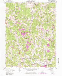
1961 Map of New Plymouth
USGS Topo · Published 1985About this map
The hills of Vinton and Hocking Counties are defined here by a legacy of resource extraction and secluded rural settlements. Centered on New Plymouth, the map captures the extensive footprint of the coal industry, with numerous Strip Mine and Reclaimed Strip Mines appearing throughout the Wayne National Forest. These industrial scars contrast with the preserved natural drainage of Fivemile Creek and Scott Creek which carve through the high ridges.
Find a feature on this map
43 named features on this map. Tap any name to fly to it.
Don’t see what you’re looking for? This feature index may not catch every label — zoom into the map to look around manually.
Map Details
Editions of this 1961 New Plymouth Map
4 editions found
Other maps of this area

1904 · Zaleski
USGS Topo · 1:62,500

1907 · Zaleski
USGS Topo · 1:62,500

1907 · Logan
USGS Topo · 1:62,500

1907 · Lancaster
USGS Topo · 1:62,500

1909 · Lancaster
USGS Topo · 1:62,500

1909 · Logan
USGS Topo · 1:62,500

1910 · Laurelville
USGS Topo · 1:62,500

1912 · Laurelville
USGS Topo · 1:62,500

1944 · Laurelville
USGS Topo · 1:62,500

1947 · Columbus
USGS Topo · 1:250,000