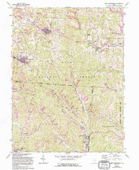
1961 Map of New Straitsville
USGS Topo · Published 1995About this map
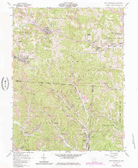
Extensive extraction operations define this 1960s landscape, with dozens of Strip Mine sites and several Tipple locations scattered across the coal-bearing hills of the Wayne National Forest. The settlement pattern follows the narrow valleys of Monday Creek and Snow Fork, where mining towns like Shawnee and Murray City developed along now Abandoned railroad corridors. In New Straitsville, industrial heritage is visible through the Brick Kilns and the St Augustine Ch sitting above the town center. The map also documents a complex web of infrastructure, including a Telephone line and multiple Pipeline routes traversing the ridges. Local social history is captured through rural landmarks like the Mt Zion Ch, the Shawnee Cem, and the Athletic Field in New Town, reflecting the community life that persisted alongside the heavy industry of the Hocking Valley coal region.
Find a feature on this map
55 named features on this map. Tap any name to fly to it.
Don’t see what you’re looking for? This feature index may not catch every label — zoom into the map to look around manually.
Map Details
Editions of this 1961 New Straitsville Map
6 editions found
Other maps of this area

1903 · Athens
USGS Topo · 1:62,500

1904 · Zaleski
USGS Topo · 1:62,500

1905 · Athens
USGS Topo · 1:62,500

1907 · Zaleski
USGS Topo · 1:62,500

1907 · Logan
USGS Topo · 1:62,500

1909 · Logan
USGS Topo · 1:62,500

1911 · New Lexington
USGS Topo · 1:62,500

1947 · Columbus
USGS Topo · 1:250,000

1961 · Columbus
USGS Topo · 1:250,000

1961 · Nelsonville
USGS Topo · 1:24,000