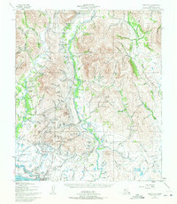
1950 Map of Nome C-1
USGS Topo · Published 1972About this map
Nome and its gold-bearing surrounds are documented here at a mid-century pivot point, showing the enduring legacy of the Seward Peninsula's mining boom. Traces of the massive hydraulic engineering required for placer mining dominate the landscape, with Elevated Ditches, a prominent Abandoned Ditch, and extensive Tailings Piles lining the watercourses. The infrastructure of the era is remarkably visible, from the coastal Landing Strip and Nome Radio Sta to the inland path of the Seward Peninsula RR and the Teller Road.
Find a feature on this map
134 named features on this map. Tap any name to fly to it.
Don’t see what you’re looking for? This feature index may not catch every label — zoom into the map to look around manually.
Map Details
Editions of this 1950 Nome C-1 Map
4 editions found
Other maps of this area

1950 · Nome D-2
USGS Topo · 1:63,360

1950 · Nome
USGS Topo · 1:250,000

1950 · Solomon C-6
USGS Topo · 1:63,360

1950 · Nome B-1
USGS Topo · 1:63,360

1950 · Solomon B-6
USGS Topo · 1:63,360

1950 · Solomon
USGS Topo · 1:250,000

1950 · Solomon D-6
USGS Topo · 1:63,360

1950 · Nome D-1
USGS Topo · 1:63,360

1950 · Nome C-2
USGS Topo · 1:63,360

1950 · Nome C-1
USGS Topo · 1:63,360