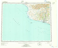
1950 Map of Nome
USGS Topo · Published 1956About this map
Nome sits at the heart of this mid-century coastal landscape, serving as the primary hub for the southern Seward Peninsula where the Snake River meets the Bering Sea. The map captures the infrastructure of the post-gold rush era, featuring active sites like Bessie No 8 Dredge Camp and Jensens Camp alongside the established Nome Airport. This survey reveals a complex network of seasonal travel, most notably the Winter Trail that weaves through the foothills of the Kigluaik Mountains.
Find a feature on this map
92 named features on this map. Tap any name to fly to it.
Don’t see what you’re looking for? This feature index may not catch every label — zoom into the map to look around manually.
Map Details
Editions of this 1950 Nome Map
5 editions found
Other maps of this area

1950 · Bendeleben A-6
USGS Topo · 1:63,360

1950 · Nome D-2
USGS Topo · 1:63,360

1950 · Nome D-4
USGS Topo · 1:63,360

1950 · Nome
USGS Topo · 1:250,000

1950 · Solomon C-6
USGS Topo · 1:63,360

1950 · Nome B-1
USGS Topo · 1:63,360

1950 · Teller
USGS Topo · 1:250,000

1950 · Bendeleben
USGS Topo · 1:250,000

1950 · Solomon B-6
USGS Topo · 1:63,360

1950 · Teller A-2
USGS Topo · 1:63,360