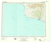
1950 Map of Nome
USGS Topo · Published 1959About this map
The Seward Peninsula coastline meets the Bering Sea in this mid-century portrait of the Alaskan interior and coast. The city of Nome serves as the focal point, situated at the mouth of the Snake River where the land gives way to Norton Sound. This survey captures the region's industrial and logistical footprint, featuring a Dredge Camp and the mining-related Bessie No 5 label, along with the Winter Trail cutting through the landscape.
Find a feature on this map
78 named features on this map. Tap any name to fly to it.
Don’t see what you’re looking for? This feature index may not catch every label — zoom into the map to look around manually.
Map Details
Editions of this 1950 Nome Map
5 editions found
Other maps of this area

1950 · Bendeleben A-6
USGS Topo · 1:63,360

1950 · Nome D-2
USGS Topo · 1:63,360

1950 · Nome D-4
USGS Topo · 1:63,360

1950 · Nome
USGS Topo · 1:250,000

1950 · Solomon C-6
USGS Topo · 1:63,360

1950 · Nome B-1
USGS Topo · 1:63,360

1950 · Teller
USGS Topo · 1:250,000

1950 · Bendeleben
USGS Topo · 1:250,000

1950 · Solomon B-6
USGS Topo · 1:63,360

1950 · Teller A-2
USGS Topo · 1:63,360