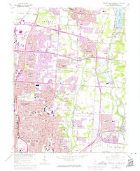
1964 Map of Northeast Columbus
USGS Topo · Published 1974About this map
Otterbein College serves as a prominent anchor in Westerville on this 1964 survey, which documents the rapid suburban transformation of northeast Columbus. The landscape is defined by the corridors of Alum Creek and Big Walnut Creek, where the newly constructed Interstate 71 and Interstate 270 begin to reshape former agricultural lands into residential tracts like Huber Ridge and Minerva Park. Smaller, older clusters such as Central College, Parks Mills, and Mifflinville appear alongside family-named sites like Otterbein Cem and Central Cem. This edition includes 1973 revisions shown in purple, highlighting the physical expansion of the city's reach toward the Hoover Reservoir. The Penn Central rail line still cuts through the terrain, providing a look at the infrastructure that preceded the highway-driven growth of the late twentieth century.
Find a feature on this map
85 named features on this map. Tap any name to fly to it.
Don’t see what you’re looking for? This feature index may not catch every label — zoom into the map to look around manually.
Map Details
Editions of this 1964 Northeast Columbus Map
4 editions found
Other maps of this area

1901 · Dublin
USGS Topo · 1:62,500

1902 · Westerville
USGS Topo · 1:62,500

1903 · Dublin
USGS Topo · 1:62,500

1904 · Westerville
USGS Topo · 1:62,500

1923 · West Columbus
USGS Topo · 1:62,500

1925 · East Columbus
USGS Topo · 1:62,500

1925 · West Columbus
USGS Topo · 1:62,500

1943 · East Columbus
USGS Topo · 1:62,500

1947 · Columbus
USGS Topo · 1:250,000

1950 · Marion
USGS Topo · 1:250,000