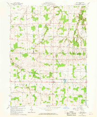
1960 Map of Nova
USGS Topo · Published 1968About this map
Agricultural lands at the junction of Ashland, Lorain, and Huron counties define this mid-century survey of North Central Ohio. The village of Nova stands as a central crossroads, while the settlement of Rochester marks the northern edge of the map. The landscape is characterized by a dense network of early transportation routes, including the Baltimore and Ohio Railroad, the New York Central Railroad, and the Akron Canton and Youngstown Railroad. These rail corridors, alongside remnants like the Old Grade, reflect the area's historical role as a transit hub for moving goods between industrial centers.
Find a feature on this map
31 named features on this map. Tap any name to fly to it.
Don’t see what you’re looking for? This feature index may not catch every label — zoom into the map to look around manually.
Map Details
Editions of this 1960 Nova Map
3 editions found

Other maps of this area

1904 · Wellington
USGS Topo · 1:62,500

1906 · Wellington
USGS Topo · 1:62,500

1906 · West Salem
USGS Topo · 1:62,500

1908 · Ashland
USGS Topo · 1:62,500

1908 · West Salem
USGS Topo · 1:62,500

1908 · New London
USGS Topo · 1:62,500

1950 · Marion
USGS Topo · 1:250,000

1956 · Toledo
USGS Topo · 1:250,000
1960 · Wellington
USGS Topo · 1:24,000

1960 · New London
USGS Topo · 1:24,000