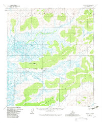
1954 Map of Ophir D-3
USGS Topo · Published 1983About this map
Innoko National Wildlife Refuge dominates this interior Alaska landscape, reflecting a region defined by extensive wetlands and meandering water systems. The map captures the complex drainage patterns of the Mud River and Galatea Creek as they wind through a mosaic of ponds and marshy lowlands. To the north, the Tlat Hills rise above the alluvial plain, mirrored to the south by the Wapoq Hills. These elevations provide the primary relief in an otherwise low-lying area where features like Cache Lake and the southern Wapoo Creek highlight the seasonal shift of the river network. Originally surveyed in the 1950s with later updates to include established federal boundaries, this sheet serves as a primary record of the Alaskan interior's hydrology and land-management history prior to modern development.
Find a feature on this map
7 named features on this map. Tap any name to fly to it.
Don’t see what you’re looking for? This feature index may not catch every label — zoom into the map to look around manually.
Map Details
Editions of this 1954 Ophir D-3 Map
2 editions found
Other maps of this area

1945 · Nulato
USGS Topo · 1:250,000

1951 · Ophir
USGS Topo · 1:250,000

1951 · Nulato
USGS Topo · 1:250,000

1952 · Nulato A-2
USGS Topo · 1:63,360

1952 · Nulato A-4
USGS Topo · 1:63,360

1952 · Nulato A-3
USGS Topo · 1:63,360

1952 · Nulato
USGS Topo · 1:250,000
1953 · Nulato A-4
USGS Topo · 1:63,360
1954 · Ophir D-4
USGS Topo · 1:63,360

1954 · Ophir C-3
USGS Topo · 1:63,360