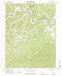
1961 Map of Otway
USGS Topo · Published 1984About this map
Otway and the surrounding township boundaries of Brush Creek, Union, and Nile define this landscape within the Virginia Military District. The topography is dominated by the Brush Creek State Forest and Shawnee State Forest, where the Norfolk and Western railway follows the valley of the South Fork Scioto Brush Creek. Genetic researchers will find numerous family burial grounds and community landmarks, such as Smith Cem, Jewett Cem, and the Beech Fork Ch located along Beech Fork Rd. Human activity is marked by scattered infrastructure like the Copperhead Lookout Tower and a Strip Mine near Henley, illustrating the 20th-century balance between resource extraction and forestry. High ridges such as Bracken Ridge and Oswego Ridge separate the many hollows and runs that drain toward the creek system.
Find a feature on this map
66 named features on this map. Tap any name to fly to it.
Don’t see what you’re looking for? This feature index may not catch every label — zoom into the map to look around manually.
Map Details
Editions of this 1961 Otway Map
3 editions found
Other maps of this area

1915 · Garrison
USGS Topo · 1:62,500

1915 · Otway
USGS Topo · 1:62,500

1916 · Peebles
USGS Topo · 1:62,500

1917 · Otway
USGS Topo · 1:62,500

1918 · Garrison
USGS Topo · 1:62,500

1918 · Peebles
USGS Topo · 1:62,500

1919 · Vanceburg
USGS Topo · 1:62,500

1949 · Pond Run
USGS Topo · 1:24,000

1949 · Vanceburg
USGS Topo · 1:62,500

1949 · Friendship
USGS Topo · 1:24,000