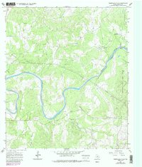
1967 Map of Pedernales Falls
USGS Topo · Published 1987About this map
The Pedernales River carves a winding path through this portion of Blanco County, defining a landscape of dramatic elevation changes and dry creek beds. Established just years after the initial field survey, Pedernales Falls State Park encompasses the notable Falls in the northeastern reach of the quadrangle. The area's mid-century character is defined by a ranching economy, visible through the presence of several private aviation sites like Baird Ranch Airfield and the Hill Ranch Landing Strip. Social life in this rural Hill Country setting centered on landmarks such as Robinson Community Hall, while the industrial presence is limited to scattered Gravel Pits. Water management and natural drainage are evident in the network of tributary ravines, including Rough Hollow and Brock Hollow, which feed into the primary river system.
Find a feature on this map
18 named features on this map. Tap any name to fly to it.
Don’t see what you’re looking for? This feature index may not catch every label — zoom into the map to look around manually.
Map Details
Editions of this 1967 Pedernales Falls Map
4 editions found
Other maps of this area

1887 · Blanco
USGS Topo · 1:125,000

1894 · Blanco
USGS Topo · 1:125,000

1954 · Llano
USGS Topo · 1:250,000

1955 · Llano
USGS Topo · 1:250,000

1956 · Llano
USGS Topo · 1:250,000
1961 · Johnson City
USGS Topo · 1:24,000

1963 · Yeager Creek
USGS Topo · 1:24,000
1963 · Henly
USGS Topo · 1:24,000
1963 · Monument Hill
USGS Topo · 1:24,000
1967 · Round Mountain
USGS Topo · 1:24,000