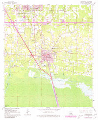
1968 Map of Ponchatoula
USGS Topo · Published 1980About this map
Ponchatoula and Hammond anchor this Tangipahoa Parish landscape, where the Illinois Central Gulf railroad serves as the primary corridor between the strawberry-growing region and the southern wetlands. The map reveals a transition from the urban grid of the two cities to the swampy reaches of the South Slough and Anderson Canal to the south. Local landmarks like the Drive-in Theater, Zemurray Park, and City Hall illustrate the mid-century community life, while various rural school sites such as Reeves Sch and Vinyard Sch reflect the historical educational layout of the parish.
Find a feature on this map
45 named features on this map. Tap any name to fly to it.
Don’t see what you’re looking for? This feature index may not catch every label — zoom into the map to look around manually.
Map Details
Editions of this 1968 Ponchatoula Map
3 editions found
Other maps of this area

1934 · Springfield
USGS Topo · 1:62,500

1935 · Ponchatoula
USGS Topo · 1:62,500

1939 · Ponchatoula
USGS Topo · 1:62,500

1939 · Springfield
USGS Topo · 1:62,500

1940 · Tickfaw
USGS Topo · 1:31,680

1942 · Robert
USGS Topo · 1:31,680

1949 · Albany
USGS Topo · 1:31,680

1951 · Ponchatoula
USGS Topo · 1:62,500

1954 · Baton Rouge
USGS Topo · 1:250,000

1956 · Baton Rouge
USGS Topo · 1:250,000