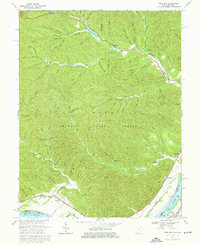
1967 Map of Pond Run
USGS Topo · Published 1976About this map
Shawnee State Forest dominates this topographic landscape, a dense network of named hollows and creek systems where the Ohio River forms the southern boundary between Ohio and Kentucky. The area is defined by its recreation and forestry infrastructure, including Turkey Creek Lake, Roosevelt Lake, and McBride Lake, alongside the Pond Run Lookout Tower for fire observation. Small riverside settlements and rail-oriented communities like Kennvale and Quincy sit along the Chesapeake and Ohio railroad corridor. Local history is preserved through scattered landmarks such as McKendree Ch, the McDermott Cem, and the Mackletree Mission. The sheer number of family-named terrain features, such as Lampblack Hollow and Cotton Eye Hollow, suggests a long history of small-scale settlement tucked into the folds of the forest before it was largely consolidated into public lands.
Find a feature on this map
80 named features on this map. Tap any name to fly to it.
Don’t see what you’re looking for? This feature index may not catch every label — zoom into the map to look around manually.
Map Details
Editions of this 1967 Pond Run Map
3 editions found
Other maps of this area

1915 · Garrison
USGS Topo · 1:62,500

1915 · Otway
USGS Topo · 1:62,500

1916 · Peebles
USGS Topo · 1:62,500

1917 · Otway
USGS Topo · 1:62,500

1918 · Garrison
USGS Topo · 1:62,500

1918 · Peebles
USGS Topo · 1:62,500

1919 · Vanceburg
USGS Topo · 1:62,500

1949 · Pond Run
USGS Topo · 1:24,000

1949 · Vanceburg
USGS Topo · 1:62,500

1949 · Garrison
USGS Topo · 1:24,000