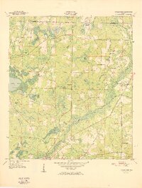
1951 Map of Poplar Head
USGS Topo · Published 1951About this map
Holmes Creek meanders through this portion of the Florida Panhandle, serving as a primary drainage for a landscape defined by expansive bays and isolated pine-land rises. In the early 1950s, the rural community structure was centered around crossroads and modest social hubs like Union Hill Sch and Bethesda Ch. The terrain transitions from the low-lying Lolly Head Bay and Dish Bay to distinct higher points such as Haddock Hill and Chalk Hill. Local landmarks like Devils Garden and Little Devils Garden hint at the difficulty of navigating the dense, water-logged depressions that cover much of the quadrangle. Transport in the era relied on the network connecting Vernon to peripheral points like Johnson Crossroad, reflecting a settlement pattern deeply tied to the natural boundaries of the numerous ponds and creeks.
Find a feature on this map
53 named features on this map. Tap any name to fly to it.
Don’t see what you’re looking for? This feature index may not catch every label — zoom into the map to look around manually.
Map Details
Editions of this 1951 Poplar Head Map
This is the sole edition of this map. No revisions or reprints were ever made.
Other maps of this area

1949 · Millers Ferry
USGS Topo · 1:24,000

1949 · Hinsons Cross Roads
USGS Topo · 1:24,000

1949 · Caryville
USGS Topo · 1:24,000

1950 · Millers Ferry
USGS Topo · 1:24,000

1950 · Hinsons Cross Roads
USGS Topo · 1:24,000

1950 · Caryville
USGS Topo · 1:24,000

1950 · Vernon
USGS Topo · 1:24,000

1950 · Chipley
USGS Topo · 1:24,000

1950 · Wausau
USGS Topo · 1:24,000

1950 · Gap Lake
USGS Topo · 1:24,000