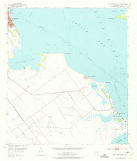
1952 Map of Port Lavaca East
USGS Topo · Published 1974About this map
Indianola Island stands as a central feature along the Texas coastline in the early 1950s, holding deep local history through the Indianola Cem and a nearby Historical Monument. This survey reveals a landscape of tidal flats and shell-bottomed waters, where the Matagorda Bay and Lavaca Bay meet. The map documents a coastal economy transitioning between traditional maritime life and industrial growth, evidenced by scattered Oil Wells and Shell Pits alongside small settlements like Magnolia Beach and Alamo Beach.
Find a feature on this map
29 named features on this map. Tap any name to fly to it.
Don’t see what you’re looking for? This feature index may not catch every label — zoom into the map to look around manually.
Map Details
Editions of this 1952 Port Lavaca East Map
4 editions found
Other maps of this area

1951 · Keller Bay
USGS Topo · 1:24,000

1952 · Port Lavaca East
USGS Topo · 1:24,000

1952 · Point Comfort
USGS Topo · 1:24,000

1952 · Olivia
USGS Topo · 1:24,000

1952 · Kamey
USGS Topo · 1:24,000

1952 · Seadrift NE
USGS Topo · 1:24,000

1952 · Seadrift
USGS Topo · 1:24,000

1952 · Port Lavaca West
USGS Topo · 1:24,000

1952 · Port O'Connor
USGS Topo · 1:24,000

1953 · Beeville
USGS Topo · 1:250,000