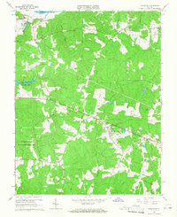
1966 Map of Powhatan
USGS Topo · Published 1968About this map
The James River forms the northern boundary of this Piedmont landscape, which centers on the rural community of Powhatan and its surrounding countryside in the mid-1960s. Educational and religious institutions anchor the settlement pattern, notably the St Emma Military Academy and St Francis de Sales Sch situated near the river at the northern edge. The area is characterized by a mix of wooded terrain and cleared fields, drained by a dense network of waterways including Fine Creek, Fighting Creek, and Gaddes Creek.
Find a feature on this map
40 named features on this map. Tap any name to fly to it.
Don’t see what you’re looking for? This feature index may not catch every label — zoom into the map to look around manually.
Map Details
Editions of this 1966 Powhatan Map
4 editions found
Other maps of this area

1890 · Goochland
USGS Topo · 1:125,000

1891 · Palmyra
USGS Topo · 1:125,000

1891 · Farmville
USGS Topo · 1:125,000

1892 · Goochland
USGS Topo · 1:125,000

1893 · Farmville
USGS Topo · 1:125,000

1895 · Palmyra
USGS Topo · 1:125,000

1897 · Amelia
USGS Topo · 1:125,000

1897 · Palmyra
USGS Topo · 1:125,000

1943 · Goochland
USGS Topo · 1:31,680

1943 · Fine Creek Mills
USGS Topo · 1:31,680