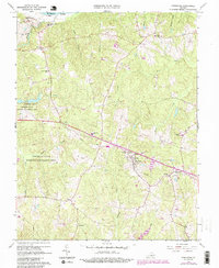
1966 Map of Powhatan
USGS Topo · Published 1987About this map
The James River forms the northern boundary of this Piedmont landscape, where the historical institutions of St Emma Military Academy and St Francis de Sales Sch stand near the riverbanks. The survey shows the transition of mid-century Powhatan County, centered on the village of Powhatan, where civic life is marked by a War Memorial, Lookout Tower, and Athletic Field. Large tracts of land are dedicated to the Powhatan State Wildlife Management Area, preserving the terrain around Salmon Creek and Salle Creek. The map documents a scattered rural network of settlements like Macon, Jefferson, and Provost, connected by roads that pass numerous country churches such as New Greenbriar Ch and Pine Hill Ch. Educational history is well-represented, from the Pocahontas High Sch to the Huguenot Academy and the older Petersville Sch.
Find a feature on this map
44 named features on this map. Tap any name to fly to it.
Don’t see what you’re looking for? This feature index may not catch every label — zoom into the map to look around manually.
Map Details
Editions of this 1966 Powhatan Map
4 editions found
Other maps of this area

1890 · Goochland
USGS Topo · 1:125,000

1891 · Palmyra
USGS Topo · 1:125,000

1891 · Farmville
USGS Topo · 1:125,000

1892 · Goochland
USGS Topo · 1:125,000

1893 · Farmville
USGS Topo · 1:125,000

1895 · Palmyra
USGS Topo · 1:125,000

1897 · Amelia
USGS Topo · 1:125,000

1897 · Palmyra
USGS Topo · 1:125,000

1943 · Goochland
USGS Topo · 1:31,680

1943 · Fine Creek Mills
USGS Topo · 1:31,680