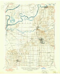
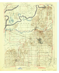
1903 Map of Princeton
USGS Topo · Published 1950About this map
The Wabash River and White River converge in this pocket of Southwest Indiana, shaping a landscape defined by meandering watercourses and low-lying wetlands like Long Pond and Cypress Ponds. While the 1903 data captures the turn-of-the-century agricultural layout, 1940s revisions reveal the growth of Princeton and Owensville, alongside the emergence of the Patoka Airport and Camp Carson. The map provides a clear look at the region's transport evolution, showing the Wabash and Erie Canal as a relic of an earlier era, now surpassed by the heavy infrastructure of the Southern and Chicago and Eastern Illinois railroads.
Find a feature on this map
55 named features on this map. Tap any name to fly to it.
Don’t see what you’re looking for? This feature index may not catch every label — zoom into the map to look around manually.
Map Details
Editions of this 1903 Princeton Map
6 editions found
Other maps of this area

1901 · Princeton
USGS Topo · 1:62,500

1901 · Haubstadt
USGS Topo · 1:62,500

1902 · Ditney
USGS Topo · 1:125,000

1902 · Boonville
USGS Topo · 1:62,500

1903 · Haubstadt
USGS Topo · 1:62,500

1903 · New Harmony
USGS Topo · 1:62,500

1903 · Petersburg
USGS Topo · 1:62,500

1903 · Princeton
USGS Topo · 1:62,500

1903 · Patoka
USGS Topo · 1:125,000

1904 · Mount Carmel
USGS Topo · 1:62,500