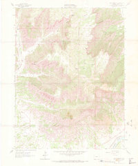
1962 Map of Red Pinnacle
USGS Topo · Published 1972About this map
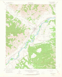
Mount Logan and Red Pinnacle dominate this vertical landscape in the early 1960s, a region defined by steep drainages and a network of primitive transport routes. The southern edge of the map shows the transition from the high plateau to the river valley, where the Colorado River runs alongside the Denver and Rio Grande Western railroad. This narrow corridor represents the primary industrial and transport artery for the area, contrasting with the wilderness to the north. A web of paths including the Jeep Trail and various unnamed Pack Trails weave through deep cuts like Bowdish Gulch and Logan Wash, providing access to isolated water sources such as Pritchard Spring. Irrigation infrastructure is also evident near the river, specifically the Bluestone Valley Ditch, which supported local agricultural efforts in this arid Garfield County terrain.
Find a feature on this map
22 named features on this map. Tap any name to fly to it.
Don’t see what you’re looking for? This feature index may not catch every label — zoom into the map to look around manually.
Map Details
Editions of this 1962 Red Pinnacle Map
4 editions found
Other maps of this area

1925 · Parachute Creek
USGS Topo · 1:62,500

1927 · Parachute Creek
USGS Topo · 1:62,500

1929 · Grand Valley
USGS Topo · 1:62,500

1929 · Highmore
USGS Topo · 1:62,500

1929 · Roan Creek
USGS Topo · 1:62,500

1956 · Grand Junction
USGS Topo · 1:250,000

1959 · Grand Junction
USGS Topo · 1:250,000

1960 · Grand Junction
USGS Topo · 1:250,000

1962 · Grand Junction
USGS Topo · 1:250,000
1962 · Grand Valley
USGS Topo · 1:24,000