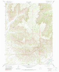
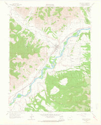
1962 Map of Red Pinnacle
USGS Topo · Published 1987About this map
Mount Logan dominates the southern skyline of this high-plateau landscape, where the terrain breaks sharply away from the peaks into a complex system of drainages. The Colorado River corridor in the southeast corner provides a striking contrast to the high country, serving as the primary artery for the Denver and Rio Grande Western railroad and the Bluestone Valley Ditch. The map reveals an area defined by its water sources, with numerous named springs such as Pritchard Spring and Hayward Spring punctuating the arid gulches. High-altitude routes like the Spruce Point Trail and various unnamed pack trails suggest a landscape used for seasonal grazing or resource access. From the heights of Haystack Mountain to the depths of Bowdish Gulch, the topography illustrates the dramatic transition between Colorado's alpine elevations and its river valleys during the early 1960s.
Find a feature on this map
25 named features on this map. Tap any name to fly to it.
Don’t see what you’re looking for? This feature index may not catch every label — zoom into the map to look around manually.
Map Details
Editions of this 1962 Red Pinnacle Map
4 editions found
Other maps of this area

1925 · Parachute Creek
USGS Topo · 1:62,500

1927 · Parachute Creek
USGS Topo · 1:62,500

1929 · Grand Valley
USGS Topo · 1:62,500

1929 · Highmore
USGS Topo · 1:62,500

1929 · Roan Creek
USGS Topo · 1:62,500

1956 · Grand Junction
USGS Topo · 1:250,000

1959 · Grand Junction
USGS Topo · 1:250,000

1960 · Grand Junction
USGS Topo · 1:250,000

1962 · Grand Junction
USGS Topo · 1:250,000
1962 · Grand Valley
USGS Topo · 1:24,000