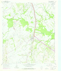
1963 Map of Richland
USGS Topo · Published 1978About this map
The Richland townsite occupies a central position on this Texas landscape, situated at the intersection of significant rail corridors and the local road network. The presence of the Powell Oil Field to the north and numerous Gravel Pits to the southwest reveals a mid-century economy driven by natural resource extraction and petroleum production. These industrial zones contrast with the low-lying wetlands of Richland Creek and its many tributaries, including Grape Creek and Oak Pin Creek.
Find a feature on this map
21 named features on this map. Tap any name to fly to it.
Don’t see what you’re looking for? This feature index may not catch every label — zoom into the map to look around manually.
Map Details
Editions of this 1963 Richland Map
2 editions found
Other maps of this area

1954 · Dallas
USGS Topo · 1:250,000

1954 · Waco
USGS Topo · 1:250,000

1955 · Waco
USGS Topo · 1:250,000

1958 · Dallas
USGS Topo · 1:250,000

1959 · Powell
USGS Topo · 1:24,000

1960 · Streetman
USGS Topo · 1:24,000

1963 · Richland
USGS Topo · 1:24,000

1963 · Wortham
USGS Topo · 1:24,000

1963 · Kirvin
USGS Topo · 1:24,000
1965 · Corsicana
USGS Topo · 1:24,000