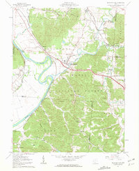
1961 Map of Richmond Dale
USGS Topo · Published 1963About this map
Richmond Dale stands as a central hub at the confluence of several early Ohio transport routes, where the Baltimore and Ohio Railroad and the Chesapeake and Ohio Railroad once converged. The landscape is defined by the winding course of the Scioto River and the rugged topography of the Wayne National Forest, which covers a significant portion of the southern hills. Local history is deeply embedded in the rural countryside, marked by numerous family and community landmarks such as Little Mound Cem, Beals Cem, and the East Jackson Sch near the settlement of Hay.
Find a feature on this map
68 named features on this map. Tap any name to fly to it.
Don’t see what you’re looking for? This feature index may not catch every label — zoom into the map to look around manually.
Map Details
Editions of this 1961 Richmond Dale Map
2 editions found
Other maps of this area

1906 · Waverly
USGS Topo · 1:62,500

1906 · Chillicothe
USGS Topo · 1:62,500

1908 · Chillicothe
USGS Topo · 1:62,500

1908 · Waverly
USGS Topo · 1:62,500

1910 · Laurelville
USGS Topo · 1:62,500

1912 · Laurelville
USGS Topo · 1:62,500

1913 · Jackson
USGS Topo · 1:62,500

1944 · Jackson
USGS Topo · 1:62,500

1944 · Laurelville
USGS Topo · 1:62,500

1947 · Columbus
USGS Topo · 1:250,000