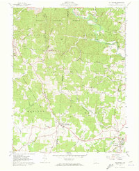
1961 Map of Rio Grande
USGS Topo · Published 1973About this map
Rio Grande College anchors the southeastern corner of this 1961 survey, serving as a cultural hub for the surrounding Appalachian foothills. The landscape is defined by the winding course of Raccoon Creek and its many tributaries, such as Little Raccoon Creek and Smoky Indian Creek. Large portions of the terrain are designated as the Wayne National Forest and the Cooper Hollow Wildlife Area, reflecting a mid-century balance between natural conservation and local industry. Evidence of the region's extractive economy is visible in several Strip Mines and a Borrow Pit near Thurman. Genealogists will find a wealth of family history preserved in numerous rural burial grounds like Lackey Cem, Rehobeth Cem, and Gilboa Cem. The map also traces the distinct ridge-and-hollow topography, where routes like Tick Ridge Road follow the high ground above deep cuts like Lackey Hollow.
Find a feature on this map
94 named features on this map. Tap any name to fly to it.
Don’t see what you’re looking for? This feature index may not catch every label — zoom into the map to look around manually.
Map Details
Editions of this 1961 Rio Grande Map
Other maps of this area

1905 · Wilkesville
USGS Topo · 1:62,500

1906 · Bidwell
USGS Topo · 1:62,500

1908 · Bidwell
USGS Topo · 1:62,500

1908 · Wilkesville
USGS Topo · 1:62,500

1912 · Oak Hill
USGS Topo · 1:62,500

1913 · Jackson
USGS Topo · 1:62,500

1944 · Jackson
USGS Topo · 1:62,500

1947 · Columbus
USGS Topo · 1:250,000

1957 · Huntington
USGS Topo · 1:250,000

1960 · Huntington
USGS Topo · 1:250,000