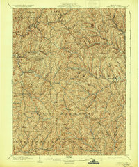
1905 Map of Rogersville
USGS Topo · Published 1930About this map
Wind Ridge P.O. and the surrounding township of Richhill exemplify the rural character of southwestern Pennsylvania at the turn of the twentieth century. The landscape is defined by an intricate network of narrow valleys and ridges, where small settlements like Jacktown and Graysville emerged along the forks of Wheeling Creek. The map documents a period when local commerce was anchored by rural post offices and mercantile hubs like Simpson Store and Harveys P.O., predating the modernization of the road network.
Find a feature on this map
84 named features on this map. Tap any name to fly to it.
Don’t see what you’re looking for? This feature index may not catch every label — zoom into the map to look around manually.
Map Details
Editions of this 1905 Rogersville Map
4 editions found
Other maps of this area

1901 · Amity
USGS Topo · 1:62,500

1901 · Waynesburg
USGS Topo · 1:62,500

1902 · Wheeling
USGS Topo · 1:62,500

1903 · Littleton
USGS Topo · 1:62,500

1904 · Amity
USGS Topo · 1:62,500

1904 · Blacksville
USGS Topo · 1:62,500

1904 · Waynesburg
USGS Topo · 1:62,500

1904 · Cameron
USGS Topo · 1:62,500

1905 · Mannington
USGS Topo · 1:62,500

1905 · Rogersville
USGS Topo · 1:62,500