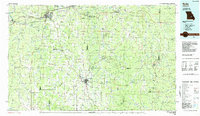
1986 Map of Rolla
USGS Topo · Published 1986About this map
Rolla serves as the primary hub of this 1980s landscape, situated at the junction of Interstate 44 and U S 63. The region is defined by the deep dissection of the Ozark Plateau, where the Meramec River and Gasconade River systems carve through dense timberlands. Large tracts of the Mark Twain National Forest and the Indian Trail State Forest dominate the southern and eastern reaches, preserving a rugged topography that resisted the dense development seen along the rail corridors.
Find a feature on this map
61 named features on this map. Tap any name to fly to it.
Don’t see what you’re looking for? This feature index may not catch every label — zoom into the map to look around manually.
Map Details
Editions of this 1986 Rolla Map
2 editions found
Other maps of this area

1888 · Tuscumbia
USGS Topo · 1:125,000

1894 · Tuscumbia
USGS Topo · 1:125,000

1901 · De Soto
USGS Topo · 1:125,000

1903 · Sullivan
USGS Topo · 1:125,000

1906 · Potosi
USGS Topo · 1:62,500

1912 · Rolla
USGS Topo · 1:62,500

1924 · Edgehill
USGS Topo · 1:62,500

1926 · Edgehill
USGS Topo · 1:62,500

1928 · Meramec Spring
USGS Topo · 1:62,500

1932 · Steelville
USGS Topo · 1:48,000