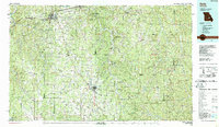
1986 Map of Rolla
USGS Topo · Published 1987About this map
The Ozark Highlands around Rolla and Salem are defined by an intricate network of waterways and early industrial sites in this mid-1980s topographic survey. The landscape is heavily wooded, dominated by the Mark Twain National Forest and various state-managed lands like the Indian Trail State Forest. Transport corridors such as the St. Louis-San Francisco Railway and I-44 cut through the hills, connecting smaller communities like Steelville, Newburg, and St James.
Find a feature on this map
105 named features on this map. Tap any name to fly to it.
Don’t see what you’re looking for? This feature index may not catch every label — zoom into the map to look around manually.
Map Details
Editions of this 1986 Rolla Map
2 editions found
Other maps of this area

1888 · Tuscumbia
USGS Topo · 1:125,000

1894 · Tuscumbia
USGS Topo · 1:125,000

1901 · De Soto
USGS Topo · 1:125,000

1903 · Sullivan
USGS Topo · 1:125,000

1906 · Potosi
USGS Topo · 1:62,500

1912 · Rolla
USGS Topo · 1:62,500

1924 · Edgehill
USGS Topo · 1:62,500

1926 · Edgehill
USGS Topo · 1:62,500

1928 · Meramec Spring
USGS Topo · 1:62,500

1932 · Steelville
USGS Topo · 1:48,000