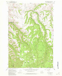
1967 Map of Rose Springs
USGS Topo · Published 1982About this map
Umatilla National Forest dominates the southern half of this landscape, where the Blue Mountains rise toward high ridges and secluded springs. The terrain is defined by dramatic elevation changes between Stevens Ridge and Scoggin Ridge, carved out by the winding Pataha Creek. In the northern foothills, agricultural and ranching life centers around Columbia Center and the various family-named hills like Calloway Hill and Tatman Mtn. This 1967 survey captures the area’s reliance on vital water sources and forest access, documented through numerous named features like Rose Springs, Lanzie Spring, and Sawmill Spring. The network of unimproved roads and jeep trails, including Bosley Grade Road, illustrates the rugged transit patterns used by local ranchers and foresters before modern paving reached many of these high-altitude points like Abels Point.
Find a feature on this map
46 named features on this map. Tap any name to fly to it.
Don’t see what you’re looking for? This feature index may not catch every label — zoom into the map to look around manually.
Map Details
Editions of this 1967 Rose Springs Map
Other maps of this area

1937 · Pomeroy
USGS Topo · 1:96,000

1942 · Pomeroy
USGS Topo · 1:125,000

1943 · Peola
USGS Topo · 1:62,500

1943 · Saddle Butte
USGS Topo · 1:62,500

1946 · Saddle Butte
USGS Topo · 1:62,500

1946 · Peola
USGS Topo · 1:62,500

1955 · Pullman
USGS Topo · 1:250,000

1958 · Pullman
USGS Topo · 1:250,000

1967 · Rose Springs
USGS Topo · 1:24,000

1967 · Hopkins Ridge
USGS Topo · 1:24,000