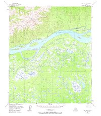
1953 Map of Ruby D-4
USGS Topo · Published 1967About this map
The Yukon River carves a massive path through this landscape, flanked by the northern peaks of the Kokrines Hills and an intricate network of waterways to the south. Near the settlement of Kokrines, an Abandoned Telegraph Line traces the riverbank, a remnant of early Alaskan communication infrastructure that preceded modern aviation and radio. The northern bank is characterized by the dramatic White Cliffs, while the southern floodplain is a dense mosaic of wetlands, defined by the winding Junekaket Slough and Deer Creek.
Find a feature on this map
25 named features on this map. Tap any name to fly to it.
Don’t see what you’re looking for? This feature index may not catch every label — zoom into the map to look around manually.
Map Details
Editions of this 1953 Ruby D-4 Map
2 editions found
Other maps of this area

1951 · Ruby
USGS Topo · 1:250,000

1951 · Melozitna
USGS Topo · 1:250,000

1952 · Ruby D-4
USGS Topo · 1:63,360

1952 · Ruby D-5
USGS Topo · 1:63,360

1952 · Ruby C-3
USGS Topo · 1:63,360

1952 · Ruby C-5
USGS Topo · 1:63,360

1952 · Ruby D-3
USGS Topo · 1:63,360

1952 · Ruby C-4
USGS Topo · 1:63,360

1952 · Ruby
USGS Topo · 1:250,000

1953 · Melozitna A-4
USGS Topo · 1:63,360