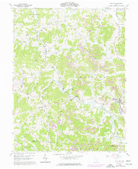
1960 Map of Rutland
USGS Topo · Published 1977About this map
Leading Creek and its many tributaries carve a complex landscape across the townships of Rutland, Salem, and Scipio in this mid-century topographic record. The area is defined by a dense network of small rural settlements including Langsville, Dexter, and Harrisonville, many of which grew around the Conrail rail corridor that snakes through the valleys. The map reveals an economy in transition, where traditional family farms and rural life, represented by numerous family burial grounds like Pearsol Cem and Vontobritz Cem, exist alongside an expanding industrial footprint. Extensive Strip Mines are visible throughout the central and eastern portions of the quadrangle, altering the natural drainage of Grass Run and Little Leading Creek. Community life centers on landmarks such as Rutland High Sch and the Old Dexter Ch, providing essential reference points for genealogists tracing Meigs County roots.
Find a feature on this map
51 named features on this map. Tap any name to fly to it.
Don’t see what you’re looking for? This feature index may not catch every label — zoom into the map to look around manually.
Map Details
Editions of this 1960 Rutland Map
4 editions found

Other maps of this area

1905 · Wilkesville
USGS Topo · 1:62,500

1906 · Bidwell
USGS Topo · 1:62,500

1907 · Pomeroy
USGS Topo · 1:62,500

1908 · Bidwell
USGS Topo · 1:62,500

1908 · Point Pleasant
USGS Topo · 1:62,500

1908 · Wilkesville
USGS Topo · 1:62,500

1926 · Point Pleasant
USGS Topo · 1:62,500

1929 · Point Pleasant
USGS Topo · 1:62,500

1947 · Columbus
USGS Topo · 1:250,000

1957 · Huntington
USGS Topo · 1:250,000