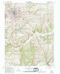
1963 Map of Salem
USGS Topo · Published 1994About this map
Salem serves as the hub of this Washington County landscape, surrounded by residential developments like Martin Heights, McCol Place, and Fair Acres. The Monon railroad corridor cuts through the terrain, connecting the county seat with smaller outposts such as Harristown, Farabee, and New Pekin. Public life is centered around the Fairgrounds and various civic institutions, including the County Home and the Filtration Plant near the banks of Brock Creek.
Find a feature on this map
39 named features on this map. Tap any name to fly to it.
Don’t see what you’re looking for? This feature index may not catch every label — zoom into the map to look around manually.
Map Details
Editions of this 1963 Salem Map
4 editions found
Other maps of this area

1941 · Borden
USGS Topo · 1:24,000

1950 · Salem
USGS Topo · 1:24,000

1950 · Becks Mill
USGS Topo · 1:24,000

1950 · Palmyra
USGS Topo · 1:24,000

1951 · Smedley
USGS Topo · 1:24,000

1953 · Fredericksburg
USGS Topo · 1:24,000

1953 · Kossuth
USGS Topo · 1:24,000

1955 · South Boston
USGS Topo · 1:24,000

1956 · Vincennes
USGS Topo · 1:250,000

1956 · Louisville
USGS Topo · 1:250,000