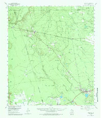
1955 Map of Saratoga
USGS Topo · Published 1984About this map
Dense river bottoms and active petroleum extraction define this corner of the Big Thicket during the mid-1950s. The Saratoga Oil Field and Batson Oil Field mark the southern landscape, where clusters of wells sit adjacent to established communities like Saratoga and Batson. The local social fabric is anchored by the Mt Calvary Ch and quiet burial grounds such as Middle Town Cem and Griffin Cem.
Find a feature on this map
45 named features on this map. Tap any name to fly to it.
Don’t see what you’re looking for? This feature index may not catch every label — zoom into the map to look around manually.
Map Details
Editions of this 1955 Saratoga Map
4 editions found
Other maps of this area

1943 · Liberty
USGS Topo · 1:125,000

1954 · Beaumont
USGS Topo · 1:250,000

1955 · Daisetta
USGS Topo · 1:62,500

1955 · Saratoga
USGS Topo · 1:62,500

1955 · Kountze
USGS Topo · 1:62,500

1955 · Sour Lake
USGS Topo · 1:62,500

1955 · Rayburn
USGS Topo · 1:62,500

1955 · Liberty
USGS Topo · 1:62,500

1957 · Beaumont
USGS Topo · 1:250,000

1958 · Livingston
USGS Topo · 1:62,500