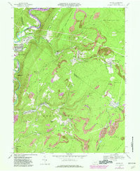
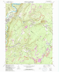
1968 Map of Saxton
USGS Topo · Published 1982About this map
Raystown Branch Juniata River and the southern reach of Raystown Lake define the western edge of this landscape, where the ridges of Allegrippis Ridge and Terrace Mountain rise above the water. In this coal-rich region of central Pennsylvania, the map reveals an extensive history of resource extraction, with numerous Strip Mines and an Old RR Grade threading through the hills. The settlement pattern is dense with small mining and railway communities like Saxton, Broad Top City, and Coalmont. Genealogists will find significant value in the documentation of several family and community burial grounds, including Evans Cem, Duvalls Cem, and Adimarie Cem, alongside landmarks such as St Michaels Ch. The transition between industrial use and conservation is evident as the State Game Lands No 67 and Warriors Path State Park encompass large tracts of the surrounding highlands.
Find a feature on this map
80 named features on this map. Tap any name to fly to it.
Don’t see what you’re looking for? This feature index may not catch every label — zoom into the map to look around manually.
Map Details
Editions of this 1968 Saxton Map
5 editions found
Other maps of this area

1900 · Everett
USGS Topo · 1:62,500

1901 · Huntingdon
USGS Topo · 1:62,500

1902 · Everett
USGS Topo · 1:62,500

1902 · Hollidaysburg
USGS Topo · 1:62,500

1903 · Hollidaysburg
USGS Topo · 1:62,500

1904 · Huntingdon
USGS Topo · 1:62,500

1930 · Broad Top
USGS Topo · 1:62,500

1933 · Broad Top
USGS Topo · 1:62,500

1953 · Pittsburgh
USGS Topo · 1:250,000

1954 · Pittsburgh
USGS Topo · 1:250,000