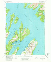
1951 Map of Seward A-3
USGS Topo · Published 1973About this map
Latouche Island and the surrounding Prince William Sound waterways reveal a landscape of early industrial activity and maritime commerce in the mid-20th century. The copper mining legacy on the island is clearly marked by several defunct operations, including the Beatson Mine (Aband) and the massive Glory Hole, alongside the townsite of Latouche (Aband). These industrial ruins contrast with the active maritime hubs of the era, such as Port Ashton and the San Juan Cannery situated on Evans Island.
Find a feature on this map
70 named features on this map. Tap any name to fly to it.
Don’t see what you’re looking for? This feature index may not catch every label — zoom into the map to look around manually.
Map Details
Editions of this 1951 Seward A-3 Map
3 editions found
Other maps of this area

1946 · Blying Sound
USGS Topo · 1:250,000

1950 · Seward B-3
USGS Topo · 1:63,360

1950 · Blying Sound D-4
USGS Topo · 1:63,360

1951 · Blying Sound
USGS Topo · 1:250,000

1951 · Seward
USGS Topo · 1:250,000

1951 · Seward A-2
USGS Topo · 1:63,360

1951 · Seward B-4
USGS Topo · 1:63,360

1951 · Seward A-3
USGS Topo · 1:63,360

1951 · Blying Sound D-1 and D-2
USGS Topo · 1:63,360

1951 · Seward A-4
USGS Topo · 1:63,360