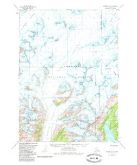
1951 Map of Seward A-5
USGS Topo · Published 1985About this map
The Sargent Icefield dominates this 1950s landscape within the Chugach National Forest, serving as the frozen heart of the Kenai Peninsula Borough. This survey captures the massive glacial systems that define the region's hydrography, showing the radial drainage of the Ellsworth Glacier to the northwest and the Chenega Glacier and Tiger Glacier to the northeast. To the south, the terrain descends toward the coast of Puget Bay, where the Puget Glacier and Excelsior Glacier meet the maritime environment. The presence of Excelsior Lake at the foot of its namesake glacier illustrates the dynamic nature of this glacial retreat and formation. High points such as Pinnacle Mountain and Puget Peak rise as nunataks and coastal landmarks above the ice and sea.
Find a feature on this map
13 named features on this map. Tap any name to fly to it.
Don’t see what you’re looking for? This feature index may not catch every label — zoom into the map to look around manually.
Map Details
Editions of this 1951 Seward A-5 Map
4 editions found
Other maps of this area

1946 · Blying Sound
USGS Topo · 1:250,000

1950 · Seward A-6
USGS Topo · 1:63,360

1950 · Blying Sound D-6
USGS Topo · 1:63,360

1950 · Blying Sound D-4
USGS Topo · 1:63,360

1950 · Blying Sound D-5
USGS Topo · 1:63,360

1951 · Blying Sound
USGS Topo · 1:250,000

1951 · Seward
USGS Topo · 1:250,000

1951 · Seward A-6
USGS Topo · 1:63,360

1951 · Seward B-4
USGS Topo · 1:63,360

1951 · Seward A-5
USGS Topo · 1:63,360