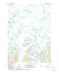
1951 Map of Seward A-5
USGS Topo · Published 1988About this map
The Sargent Ice Field dominates this high-altitude landscape within the Chugach National Forest, illustrating the massive ice-and-rock environment of the eastern Kenai Peninsula. Surveyed in the early 1950s with later revisions, the map documents the heavy glaciation of the era, where the Ellsworth Glacier, Chenega Glacier, and Bainbridge Glacier flow outward from the central ice mass. The terrain is defined by extreme relief, featuring landmarks like Pinnacle Mountain and Puget Peak, which overlook the ice-carved valleys. Along the southern coast, the Alaska Maritime National Wildlife Refuge borders the waters of Puget Bay, marking a transition from the frozen interior to the sea. This record captures the extent of the Excelsior Glacier and the adjacent Excelsior Lake before the significant environmental shifts of the late twentieth century, providing a baseline for studying glacial movement and coastline morphology in this uninhabited region.
Find a feature on this map
16 named features on this map. Tap any name to fly to it.
Don’t see what you’re looking for? This feature index may not catch every label — zoom into the map to look around manually.
Map Details
Editions of this 1951 Seward A-5 Map
4 editions found
Other maps of this area

1946 · Blying Sound
USGS Topo · 1:250,000

1950 · Seward A-6
USGS Topo · 1:63,360

1950 · Blying Sound D-6
USGS Topo · 1:63,360

1950 · Blying Sound D-4
USGS Topo · 1:63,360

1950 · Blying Sound D-5
USGS Topo · 1:63,360

1951 · Blying Sound
USGS Topo · 1:250,000

1951 · Seward
USGS Topo · 1:250,000

1951 · Seward A-6
USGS Topo · 1:63,360

1951 · Seward B-4
USGS Topo · 1:63,360

1951 · Seward A-5
USGS Topo · 1:63,360