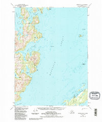
1951 Map of Seward B-2
USGS Topo · Published 1988About this map
Knight Island and Green Island dominate this coastal survey of Prince William Sound, illustrating a landscape defined by deep fjords and mineral exploration. The presence of several Mines near Iron Mountain and Drier Bay indicates early twentieth-century industrial activity focused on copper or iron extraction along the eastern shore. Small clusters of Cabins near Gibbon Anchorage provide evidence of seasonal maritime habitation and the reliance on sheltered waters like Snug Harbor and Marsha Bay for refuge. The intricate coastline, marked by features such as the Bay of Isles and Herring Bay, reveals a complex network of passages including Lower Passage and Foul Pass. These waterways served as vital corridors for vessels navigating between the larger islands and Montague Strait during the mid-century era.
Find a feature on this map
40 named features on this map. Tap any name to fly to it.
Don’t see what you’re looking for? This feature index may not catch every label — zoom into the map to look around manually.
Map Details
Editions of this 1951 Seward B-2 Map
4 editions found
Other maps of this area

1950 · Seward B-3
USGS Topo · 1:63,360

1951 · Seward
USGS Topo · 1:250,000

1951 · Seward B-1
USGS Topo · 1:63,360

1951 · Seward A-2
USGS Topo · 1:63,360

1951 · Seward A-3
USGS Topo · 1:63,360

1951 · Seward A-1
USGS Topo · 1:63,360

1951 · Seward B-2
USGS Topo · 1:63,360

1951 · Seward C-1
USGS Topo · 1:63,360

1951 · Seward C-3
USGS Topo · 1:63,360

1951 · Seward C-2
USGS Topo · 1:63,360