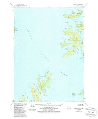
1951 Map of Seward C-2
USGS Topo · Published 1988About this map
Naked Island and its surrounding archipelago anchor this maritime survey of Prince William Sound. The map documents a landscape defined by intricate waterways and rocky outcroppings within the Chugach National Forest, ranging from the larger landmasses of Eleanor Island and Storey Island to the smaller Peak Island and Block Island. A scattered human presence is evidenced by isolated cabins along the northern shore of Naked Island and near Bass Harbor, marking a period when these islands served as remote outposts for fishing or resource management.
Find a feature on this map
25 named features on this map. Tap any name to fly to it.
Don’t see what you’re looking for? This feature index may not catch every label — zoom into the map to look around manually.
Map Details
Editions of this 1951 Seward C-2 Map
3 editions found
Other maps of this area

1950 · Seward B-3
USGS Topo · 1:63,360

1951 · Seward
USGS Topo · 1:250,000

1951 · Seward B-1
USGS Topo · 1:63,360

1951 · Seward D-2
USGS Topo · 1:63,360

1951 · Seward D-1
USGS Topo · 1:63,360

1951 · Seward B-2
USGS Topo · 1:63,360

1951 · Seward D-3
USGS Topo · 1:63,360

1951 · Seward C-1
USGS Topo · 1:63,360

1951 · Seward C-3
USGS Topo · 1:63,360

1951 · Seward C-2
USGS Topo · 1:63,360