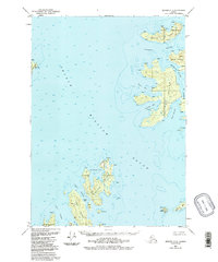
1951 Map of Seward C-2
USGS Topo · Published 1988About this map
Prince William Sound dominates this mid-century cartographic study, centered on the significant landmass of Naked Island. The map illustrates a remote maritime landscape where survival and seasonal occupation are marked by small Cabins and a singular Cabin structure tucked into the protected coves of the northern islands. The complex archipelago includes Storey Island, Peak Island, and Ingot Island, each separated by narrow, deep-water corridors such as McPherson Passage and Liljegren Passage.
Find a feature on this map
27 named features on this map. Tap any name to fly to it.
Don’t see what you’re looking for? This feature index may not catch every label — zoom into the map to look around manually.
Map Details
Editions of this 1951 Seward C-2 Map
3 editions found
Other maps of this area

1950 · Seward B-3
USGS Topo · 1:63,360

1951 · Seward
USGS Topo · 1:250,000

1951 · Seward B-1
USGS Topo · 1:63,360

1951 · Seward D-2
USGS Topo · 1:63,360

1951 · Seward D-1
USGS Topo · 1:63,360

1951 · Seward B-2
USGS Topo · 1:63,360

1951 · Seward D-3
USGS Topo · 1:63,360

1951 · Seward C-1
USGS Topo · 1:63,360

1951 · Seward C-3
USGS Topo · 1:63,360

1951 · Seward C-2
USGS Topo · 1:63,360