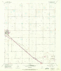
1956 Map of Shallowater
USGS Topo · Published 1971About this map
The town of Shallowater serves as a primary hub for this Lubbock County landscape, shaped significantly by the diagonal path of the Atchison Topeka and Santa Fe railroad. The terrain is characterized by the meandering Yellow House Draw, which carves through the High Plains topography, providing a distinct contrast to the surrounding agricultural grid. By the early 1970s, the map reveals specialized land uses such as the Drag Strip and Hillcrest Golf Course near the town of Broadview, indicating a shift toward suburban recreational development. Local infrastructure is further detailed through a Radio Range Sta, a Gravel Pit, and a protective Levee system. These features, along with the Athletic Fields and Sewage Disposal facility, document the post-war growth and modernization of this Texas Panhandle community as it evolved alongside major transportation corridors.
Find a feature on this map
12 named features on this map. Tap any name to fly to it.
Don’t see what you’re looking for? This feature index may not catch every label — zoom into the map to look around manually.
Map Details
Editions of this 1956 Shallowater Map
3 editions found
Other maps of this area

1954 · Lubbock
USGS Topo · 1:250,000

1954 · Brownfield
USGS Topo · 1:250,000

1956 · Shallowater
USGS Topo · 1:24,000

1956 · New Deal
USGS Topo · 1:24,000

1957 · Lubbock East
USGS Topo · 1:24,000

1957 · Lubbock West
USGS Topo · 1:24,000

1957 · Lubbock
USGS Topo · 1:62,500

1957 · Anton
USGS Topo · 1:62,500

1957 · Abernathy
USGS Topo · 1:62,500

1957 · Wolfforth
USGS Topo · 1:62,500