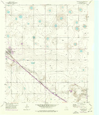
1956 Map of Shallowater
USGS Topo · Published 1976About this map
The town of Shallowater serves as a focal point on this Llano Estacado landscape, where the flat plains are interrupted by the distinct winding path of Yellow House Draw. The era’s transportation and utility infrastructure is clearly defined, with the Atchison Topeka and Santa Fe railroad cutting diagonally across the quadrangle, paralleled by a protective Levee. This mid-century survey reveals the community's development through features like the Athletic Fields and Sewage Disposal plant. Further east, the Radio Range Sta highlights the importance of regional aviation and communication technology during the 1950s. The presence of a Gravel Pit and the Hillcrest Golf Course shows the varied land use between industrial extraction and emerging recreational spaces on the outskirts of Lubbock County.
Find a feature on this map
11 named features on this map. Tap any name to fly to it.
Don’t see what you’re looking for? This feature index may not catch every label — zoom into the map to look around manually.
Map Details
Editions of this 1956 Shallowater Map
3 editions found
Other maps of this area

1954 · Lubbock
USGS Topo · 1:250,000

1954 · Brownfield
USGS Topo · 1:250,000

1956 · Shallowater
USGS Topo · 1:24,000

1956 · New Deal
USGS Topo · 1:24,000

1957 · Lubbock East
USGS Topo · 1:24,000

1957 · Lubbock West
USGS Topo · 1:24,000

1957 · Lubbock
USGS Topo · 1:62,500

1957 · Anton
USGS Topo · 1:62,500

1957 · Abernathy
USGS Topo · 1:62,500

1957 · Wolfforth
USGS Topo · 1:62,500