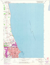
1954 Map of Sheboygan North
USGS Topo · Published 1974About this map
Sheboygan anchors this coastal survey, where the Sheboygan River winds through the city before emptying into Lake Michigan. The map illustrates a developed mid-century lakeshore, characterized by an extensive park system including Vollrath Park, Deland Park, and Cole Park along the water's edge. Industrial and civic infrastructure is prominent near the mouth of the river, with the Waterworks and City Hall clearly marked. To the north, the landscape transitions into the rural townships of Mosel, where the small settlement of Haven sits along the Chicago and North Western rail line. This 1973 photorevision documents the expansion of the city limits, highlighting newer residential blocks in purple against the established street grid and institutions like St Nickolas Hospital and North High Sch.
Find a feature on this map
32 named features on this map. Tap any name to fly to it.
Don’t see what you’re looking for? This feature index may not catch every label — zoom into the map to look around manually.
Map Details
Editions of this 1954 Sheboygan North Map
3 editions found
Other maps of this area

1954 · Sheboygan Falls
USGS Topo · 1:62,500

1954 · Sheboygan South
USGS Topo · 1:62,500

1954 · Sheboygan Falls
USGS Topo · 1:24,000

1954 · Cleveland
USGS Topo · 1:24,000

1954 · St. Wendel
USGS Topo · 1:24,000

1954 · Sheboygan North
USGS Topo · 1:62,500

1954 · Sheboygan North
USGS Topo · 1:24,000

1954 · Sheboygan South
USGS Topo · 1:24,000

1954 · Howards Grove
USGS Topo · 1:62,500

1954 · Howards Grove
USGS Topo · 1:24,000